You can blame S. Bruce of Corbridge for this second blog: “Ian, I genuinely enjoyed your post on rocks and wildlife. If we can harness even a fraction of the passion you have for inanimate things like stones and transfer it to the lads then we have a chance of playing with a bit more desire than we did in the last five matches of the season. Meantime I’m booking the squad in for your next guided walk, when is it?” Thanks Mr Bruce, not sure when the next socially distanced rock hike will be, but in the meantime maybe you and Northumberland Wildlife Trust fans might like to hear a bit more about geologists and their weird way of looking at nature when they go for a walk (not that I think it’s weird).
I live close to Hadrian’s Wall, near Twice Brewed, so the Wall Corridor, the Tyne Valleys, and the North Pennines are familiar ground. For me familiarity doesn’t breed contempt though. If you twisted my hand behind my back and made me pick one easily reachable viewpoint to explain the landscape of Northumberland it would be Steel Rigg.
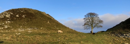
Stand on the iconic spot, ignore the archaeology and Robin Hood’s tree for a moment and gaze east. There rising and falling in front of you, like a staircase tipped backwards, is a series of escarpments and the grandest of them all is the Whin Sill.
An injection of molten rock 295 million years ago, sandwiched between existing strata just as if you’d squeezed the jam into a Victoria sponge as an afterthought. And the other escarpments; they are also hard rocks, though not quite as hard as the dolerite of the Whin Sill, they are multiple layers of sandstone and limestone, interspersed with softer shales.
So, why is the landscape shaped like this? Hard rocks resist erosion, soft rocks don’t. Millions of years of wind, rain and gravity have differentially worn this terrain down, finished off 20,000 years ago by a final planing of a slow moving ice sheet almost a kilometre thick.
Even the melting of that ice left its mark. Ever feel those many ups and downs of along the central section of the Hadrian’s Wall trail can get a bit tiresome? Blame glacial meltwater as it broke through the Whin Sill to reach the lower ground of the Tyne Valley and created the gaps and nicks.
I’m guessing some of my friends who regularly go walking with me will be nodding now. “We’ve been here 10 minutes and we haven’t walked 500 metres." Which is why nowadays I’m usually only allowed to mention the word geology when they specifically ask me a question.
I had intended to tell you about some neglected countryside north of the Wall where, within the ranks of Sitka spruce, you can find old quarries and rocky escarpments with abundant fossil bivalves (sea shells) and corals - evidence of clear sub-tropical seas 320 million years ago. About the bogs and flows that tell us so much about the way our planet warmed up 12,000 years ago and wildlife colonised the tundra. Not to mention a walk down a burn every bit as pretty as Jesmond Dene, but much less busy; it’s full of examples of the influence of rocks on man and the landscape.
But they will have to wait for another day because I’ve already exceeded my word limit. Did I mention that geologists have trouble with that?


